beers
beers
-
- Out of Stock
- Sync, US States
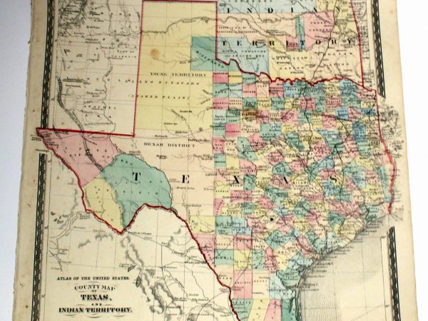
No. 3639 Texas and Indian Territory (Oklahoma), 1875
- "County Map of Texas and Indian Territory" from H.H. Lloyd & Co.'s "Atlas of the United States" published by Warner & Beers in New York, 1875 with hand-coloring slightly uncommon map in that it shows the entire state of Texas on one map (most maps of the time show either the eastern or northern panhandles on separate insets) as well…
- Read more
-
-
- Sync, other Westchester areas
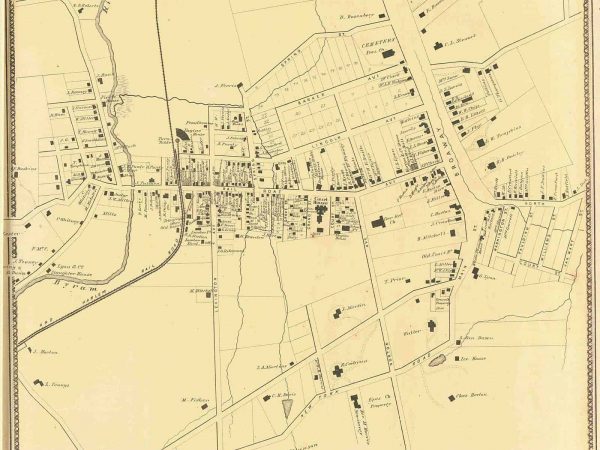
No. 595 White Plains, 1867
- $65.00
- White Plains from F.W. Beers, Ellis & Soule's "New York & Its Vicinity From Actual Surveys By and Under the Direction of F.W. Beers" published in 1867 measures approx 14 1/2" x 17 1/2"
- Add to cart
-
- Sync, New York State, US States
No. 598 New York State, 1872
- $525.00
- New York State (including Railroad Lines) from Beers' Atlas of Monroe County New York published in 1872 measures approx 24" x 15 1/2"
- Add to cart
-
- Out of Stock
- Rye & Harrison
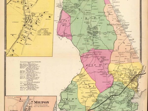
No. 4054 Harrison & Rye, 1868
- Towns of Harrison and Rye, Westchester County with insets of Milton by F.W. Beers from his "Atlas of Westchester County" published in New York, 1868 hand coloring measures approx 18" x 25"
- Read more
-
-
- Out of Stock
- Sync, Rye & Harrison
No. 3926 Harrison & Rye, 1868
- Towns of Harrison and Rye, Westchester County insets of Milton and downtown Rye by F.W. Beers from his "Atlas of Westchester County" published in New York, 1868 hand coloring measures approx 18" x 25"
- Read more
-
-
- Out of Stock
- Sync, US Cities, New York City
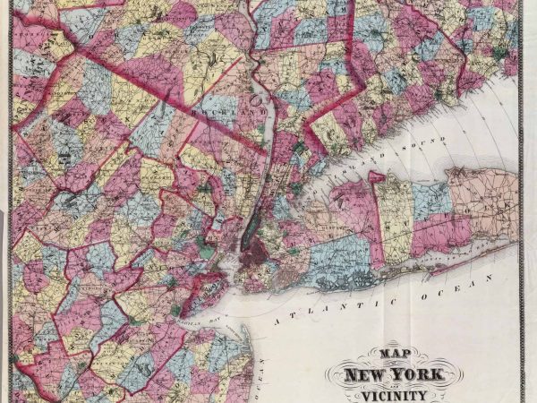
No. 3236 New York City Vicinity, 1867
- "Map of New York and Vicinity" by F.W. Beers from his "Atlas of New York and Vicinity" published by Beers, Ellis & Soule, New York 1867 nice large and colorful map showing the greater New York City area, including parts of Long Island, Westchester, Connecticut and New Jersey measures approx 30" x 28″
- Read more
-
-
- Sync, New York State, US States
No. 1640 New England & New York, 1872
- $50.00
- "New England and New York" from H.H. Lloyd & Co.'s "Atlas of the United States" published by Warner & Beers in New York, 1872 measures approx 17" x 13 1/2"
- Add to cart
-
- Out of Stock
- Sync, US States
No. 709 Massachusetts, Rhode Island & Connecticut, 1870
- "Plan of Massachusetts, Rhode Island and Connecticut" by F.W. Beers from his "Atlas of Hampden County Massachusetts" published in New York, 1870 measures approx 15 1/2" x 13"
- Read more
-
-
- Sync, other Westchester areas
No. 4062 Beekmantown, Tarrytown, Irving 1867
- $175.00
- Beekmantown, Tarrytown & Irving from F.W. Beers, Ellis & Soule's "New York & Its Vicinity From Actual Surveys By and Under the Direction of F.W. Beers" published in 1867 measures approx 26" x 19"
- Add to cart
-
- Out of Stock
- Sync, Larchmont & Mamaroneck
No. 611 Mamaroneck & Orienta, 1867
- Mamaroneck with inset of Orienta from F.W. Beers, Ellis & Soule's "New York & Its Vicinity From Actual Surveys By and Under the Direction of F.W. Beers" published in 1867 measures approx 14 1/2" x 17 1/2"
- Read more
-
-
- Sync, Larchmont & Mamaroneck, Rye & Harrison
No. 610 Mamaroneck & Rye Neck, 1867
- $150.00
- Mamaroneck & Rye Neck from F.W. Beers, Ellis & Soule's "New York & Its Vicinity From Actual Surveys By and Under the Direction of F.W. Beers" published in 1867 measures approx 14 1/2" x 17 1/2"
- Add to cart
-
- Out of Stock
- Sync, Larchmont & Mamaroneck, Rye & Harrison, other Westchester areas
No. 2634 Mamaroneck, Scarsdale, White Plains, Rye 1867
- Mamaroneck, Scarsdale, White Plains, Rye from F.W. Beers, Ellis & Soule's "New York & Its Vicinity From Actual Surveys By and Under the Direction of F.W. Beers" published in 1867 measures approx 14 1/2" x 17 1/2"
- Read more
-